A much needed sleep in. Woke at 8:30, down the lift,
wandered through the building complex and found a café for a relaxed breakfast.
We ambled down to the beach, seeing half dozen blunt tailed lizards in the park
along on the way then took a stroll along the beach front before returning via the
busy, noisy road to our rooms for an appreciated respite - Kath & Russell
in the spa, Wendy for pedicure & manicure and me at the computer in our
room with views over the coast. Bliss - fast, free internet in the lobby!
Thursday 18th October: Lancelin – Perth 187km Russell lead
Happy birthday to you
Happy birthday to you.
Happy birthday dear Kath
Happy birthday to you
Kath’s birthday – “Oh my” what a day!
On our way through to Perth we called in at the Gravity
Discovery Centre; a working observatory combined with a large interactive
learning centre on gravity and cosmology. Fascinating, but it did my head in –
sound waves, light waves, black holes, gravity - all heady stuff. The climb up
the leaning tower to drop water bombs was cool – 180 tonnes of steel, 222
steps, 45 meters high, 15 degrees of inclination – and the 360 degree view from
the top was pretty spectacular too. On to Perth, hired a car then proceeded to
drop the campervans back off 2 blocks away. Do we blame the Navman or the
Navigator? The map shows 167km from Lancelin to Perth plus a little bit to the
Discovery Centre but we ended up doing 187km for the day. Now, I ask you, do
you really think it takes 1 ½ hours to drive 2 blocks? The short answer is yes,
it can do! Finally after much stress, one lead vehicle and two following vehicles,
through traffic lights, intersections, motorways, side streets all without
losing one another we made it – late, but we made it. A grand total of 7,252km.
We drove across Perth to the northern suburb of Scarborough to The Rendezvous
Hotel on the waterfront. A palatial place, in the middle of renovations, where we
were lucky enough to get a renovated room with views north up the coast and its
own private little balcony. Across the street, we found a lovely restaurant for
the double celebration of Kath’s birthday, where Russ presented her with a
gorgeous pearl necklace inspirationally designed on the Staircase to the Moon
theme, and the successful completion of the 4 wheeling part of our holiday. After
dinner, it was back to our exquisitely comfortable rooms for a blissful night’s
sleep.
Wednesday 17th October: Geraldton – Lancelin 336km Wendy lead
Rain! During the night, for the first time in 3 weeks, we
heard rain for about 10 minutes. While Jan cooked us bacon, eggs, beans and
toast I commandeered her computer and while watching “Red Dog” (a 1970’s
Pilbara icon – more tissues Kath?) managed to finally get the blog up-to-date
for the first time. Finally left Geraldton and heading down the coast we got
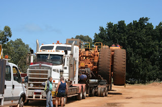
caught behind one of the widest loads we had seen at 7.5 meters. It literally
took up both lanes of the road and even road trains had to park up well off the
road for it to pass. The massive trailer carrying the load looked like a toy.
We turned off onto Indian Ocean Drive stopping at the seaside town of Leeman
for morning tea, complete with flies and wind, continuing on to Cervates for
lunch with, you guessed it, the inevitable flies and wind. Had a good look
around at the “Pinnacles” which we found quite fascinating; limestone columns
up to 3 meters high protruding from desert sands. “Rising mysteriously from the
dune sands are thousands of limestone pillars, a landscape in eerie contrast to
the surrounding heath.” Well worth the visit. We ended the day in Lancelin, yet
another seaside town with flies and wind, in a run-down campground having now clocked
up 7,000km.
Tuesday 16th October: Geraldton 66km Kath lead
Geraldton – Mid West Wheat Belt so the radio station
keeps proclaiming but what it doesn’t mention is, since dropping below the
Tropic of Capricorn, the flies, the constant westerly wind and the cooler
evenings and nights. Jan & Andrew offered for us to stay the night on their
back lawn and Jan clinched the deal with a promise of a pork roast for dinner
so we spent a quiet day around Geraldton. We started with a walk through of the
old goal now used as a craft market with most of the old cells used as craft stalls.
Next it was on to McDonald’s for coffee with the intention of using their wi-fi
to update this blog. The place was cold, the wi-fi slow and kept dropping off.
Kath & Russell left as us to it and wandered around town and after a couple
of hours Wendy & I gave up as well. Met up with Russell & Kath again
and had a crappy lunch in a run-down mall. Russell led us on a drive by tour of
the town before separating and having a meander around Geradton on our own.
Found a few places of interest; the port, beaches and the sight of the first
light house and the keeper’s house. There have been 11 shipwrecks off Geraldton
starting in 1629 with the Batavia (quite a gruesome story relating to the
survivors) through to 1936. Due to the dangerous reef crossing, quite an
ingenious way to assist ships navigate their way through the reef into harbour was
used. One lighthouse was built on the shore line and another on the hill
behind. The ships captain’s would position their ships so the two lights were
in alignment and sail directly towards them through the opening in the reef.
Caught up again with Russell & Kath and arrived at Jan & Andrew’s for a
chin wag and our promised roast. Thank you Jan for a truly magnificent meal and
to you both for your generous hospitality.
Monday 15th October: Kalbarri – Geraldon 216km Warwick lead
On leaving Kalbarri we headed down the coast stopping in at many of the lookouts along the bluffs. All very spectacular with their red layered rock formations and at one of them we could even watch whales swimming by in the distance. Leaving sight of the coast line we continued on south where the road took us along the banks of the Hutt Lagoon at the bottom end of which we turned back up the coast to the little seaside resort of Gregory. The lagoon had a pink tinge to it and later on we found out that this caused by an algae bloom and in season the entire lagoon is a very bright pink. Heading back inland to once again connect up to the North West Coastal Highway at the very old historic farming town of Northampton where we had our lunch stop. From Northampton it was just a short hop down to Geraldton on the coast. Geralton is about the same size as Whangarei, full of historic buildings with still a thriving port and railway. After booking in at camp we took a leisurely drive around the town before the inevitable grocery shop. Wendy phoned friends, Andrew and Jan from Kerikeri, now living over here and they came over to visit us at camp. A delightful couple and being jeep owners they were immediate friends of Russell & Kath.
Sunday 14th October: Hamelin Pool – Kalbarri 342km Russell lead
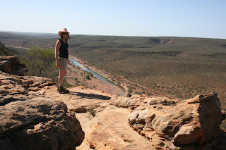
After breakfast we went for a walk up the hill behind the camp/telegraph station, to the shell quarry onto the Stromatolites and back to camp. Drove back to the Overlander Roadhouse on the North West Coastal Highway to refuel and air up before continuing along on a straight we started a couple of days ago before turning off to Steep Point. The straight – 102.8km in total! Towards the turn off to Kalbarri we started noticing trees along the side of the road rather than shrubs and a while later saw cultivated farm land with fields of wheat. Turning off to Kalbarri we meandered through the Kalbarri National Park calling in at several lookouts all offering spectacular views over the Murchison River. We arrived in Kalibarri a modern and picturesque town situated on the coast at the mouth of the Murchison River.
Saturday 13th October: Monkey Mia – Hamelin Pool 424km Wendy lead
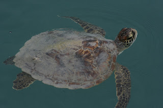
We were woken before dawn with vehicles leaving very early, possibly to go fishing. Got up at dawn and wandered down to the beach. Not a breath of wind, water as smooth as glass and within 50 meters of shore we watched 4 dolphins feeding and a stingray glide by within a meter of shore. After breakfast we broke camp and waited for the dolphin interaction display the resort puts on each morning, although it’s up to the dolphins if they decide to turn up or not. While waiting, a turtle swam past close to shore. With a big day ahead of us we couldn’t wait for the dolphins to appear and as we had already seen them feeding for themselves we left Monkey Mia at 8:30. Back down the Peron Peninsula 100km, hung a right for 40km, then another right.heading north west. The road changing from sealed to wide dirt, to narrow & corrugated and finally single lane and sandy. We came to a hill that was all soft sand, without knowing how long, steep or how many more to follow we aired down and made a run for it. Clawed our way to the top and down the other side. Finally made it to Steep Point – westernmost point of mainland Australia. The return trip wasn’t quite as bad but very thankful that we hadn’t met another vehicle on the track. We made it back fairly late to Hamelin Pool at the base of the Peron Peninsula and stayed at a camp ground the complete opposite to the previous night. Small with few other campers and a very friendly & knowledgeable staff it was a real gem. On arriving we were given a tour of the old telegraph exchange and told a little of the history of the place. The telegraph was established in the 1800’s as a repeater station. Back in those days, before the advent of the telephone, messages were sent by morse code but the power could only transmit a signal 100miles so repeater stations were set up all along the coast. There is an old disused quarry just back from the shoreline for mining shell blocks. Unlike Shell Beach we visited previously where the shells are loose; these shells are cemented together by rain leeching the calcium from the shells and being compacted down under pressure. The deposits are up to 8 meters deep and are cut out using hand saws into blocks which were used for building. Hamelin Bay itself is unique. At its entrance there is a natural sand bank so the tidal movement is restricted to about 300mm. With the pool only about 1,200mm deep, high temperatures and little rain resulting in high evaporation the salinity of the water is 2 ½ times that of the ocean which keeps the sea slugs and snails out – the natural predators of Stromatolites. Now, what are Stromatolites I hear you ask. Quite simply, without them you may not be here. They are, literally, living rocks. Formed in colonies by single-celled microbes growing at only .3mm per year. They’ve been around for 3.5 billion years when there was only 1% oxygen in the atmosphere and as they release oxygen, they were the main contributor of raising the oxygen level to 21% helping create the environment for all other living organisms. It took another billion years for two types of bacteria to merge to form a more complex single-celled organism establishing the building block for the later evolution of higher life forms. Come to think of it, I know a few humans that are very closely related to Stromatolites.
Friday 12th October: Carnarvon – Monkey Mia 365km Kath lead
Bacon and eggs for breakfast – a treat! We travelled
south for an hour from Carnarvon stopping at White Bluff Lookout with 360
degree panoramic views before crossing the 26th Parallel. We turned
off at Overlander Roadhouse to head up the Peron Peninsula. With the cooler
climate, wildflowers were again on display. We stopped in at Shell Beach made
up of billions of tiny cockle shells. Although unusual it was still very picturesque
especially with the turquoise water lapping the shore. Continuing on we called
in at Goulet Bluff Lookout followed by Eagle Bluff Lookout. Magnificent bluffs,
overlooking the bay where the water was so clear we could see a ray gliding
along the sea floor while further out we could see the dark blue water where
the seagrass was growing. Continuing north we crossed the 26th
Parallel again and a little further on stopped at Denham for our latest lunch
yet. Crossed over to the eastern side of the peninsula and arrived at our
destination of Monkey Mia (Eastern Bluff) to a full campsite so ended up
setting up in the campground carpark. Monkey Mia is a tourist resort and charge
accordingly. Situated ½ way up the peninsula facing east towards the mainland
about 30km away and north up Shark Bay into the Indian Ocean.
Thursday 11th October: Coral Bay – Carnarvon 372km Warwick lead
We awoke this morning to dew covering everything! Leaving
Coral Bay we headed slightly inland and crossed the Tropic of Capricorn at,
unbelievably, exactly 5,0000km since
starting our trip. 80km after leaving Coral Bay we met up with the North West
Coastal Highway and continued on until we were 25km north of Carnarvon where we
turned back north along the coast passing Lake McLeod and the Dampier fear Salt
Mine. Covering 2,072 sq km it is only separated from the sea by sand dunes.
There is no of drowning in this lake as it was totally dry. Even in the wet it
would barely be ½ meter deep. A little further on we drove up to a lighthouse where
we had expansive views of the surrounding countryside, coast line and
blowholes. Drove down to the blowholes and they were quite something; the noise
sounded like a train coming through and they reached quite a height. The spray
drift caused small pockets of sea water to collect in the surrounding rocks and
with so much sun and so little rain the water evaporated leaving behind salt
crystals around the edges. A little further north we stopped for lunch at the
HMAS Sydney II memorial. On 19th November 1941 the HMAS Sydney II
intercepted the German Raider Kormoran. In the ensuring battle both ships were
sunk with the Kormoran suffering 80 fatalities while all 645 on board the
Sydney were lost. This was Australia’s worst maritime loss of the Second World
War. Turning around we got into Carnarvon mid-afternoon, booked into the camp
and while Wendy & I visited the Gascoyne Aboriginal Heritage and Cultural
Centre Russell & Kath toured the town. After the Heritage Centre we drove
down to the historic One Mile Jetty and Heritage Precinct. Walking out to the
end of the jetty “Coffee Pot” the little locomotive that runs down the jetty
was coming towards us and who should it be carrying but Russell & Kath. Getting
back off the jetty we climbed the old water tower offering expansive views of
the jetty, the old railway yards, the mouth of the Gascoyne River and Carnarvon
itself. Carnarvon is situated at the only point of the coastline where the
central desert reaches to the sea. It also produces 70% of WA’s winter
vegetable requirements, (obviously they don’t eat a lot of winter veges in WA)
and 30,000 tonnes of fruit and vegetables every year from its plantations. We
meet back at camp at 5:00 for the inevitable supermarket shopping. With enough
supplies for 4 days we headed back to camp for nibbles and dinner. The climate
is certainly changing and with the evening temperate dropping to only 22
degrees we had to don sweat shirts. L
Wednesday 10th October: Exmouth – Coral Bay 202km Russell lead
Leaving Exmouth we retraced yesterday’s sightseeing trip
past the lighthouse and continued on down the western coastline through the
Cape Range National Park, an airforce defence area and pastoral stations
(although what the sheep & goats ate, I have no idea) all overlooking the
Ningaloo Reef. Ranges to the left of us, reef to the right of us. The ranges
are still quite barren and very dry, the reef, on the other hand, beautiful
turquoise and brilliant white sand. Today promised to be our first real day of
4 wheeling starting with a creek crossing at the south end of the park at
Yardie Creek. We checked at the information centre and there wasn’t going to be
a problem with the tide – “no worries, the tide doesn’t affect the creek”. Got
there, had a look and……… disappointment. The darn creek hadn’t seen any water
for months! We saw a 4x4 airing up after having crossed from the opposite side
but decided we’d try without airing down. 45lb pressure and a heavy wallowing
brick and we still made it across with ease. Not so for a guy towing a caravan,
who had even aired down, going the opposite way, chugging along only making it
¾ of the way across before burying himself - momentum is your friend. Luckily
for him someone over the other side winched him through. The track after that
was very narrow and varied from corrugated, rough to loose sand. Great stuff
and I was driving! Although we did get up to a maximum of 60kph, we generally
cruised at 45-50 as both our bodies and the trucks couldn’t stand any more.
Thankfully we don’t own the trucks. Talk about shake, rattle and roll. 150km
latter, we made it into Coral Bay, a very small, picturesque, popular (school
holidays) seaside town. We found all sorts of things on the floor and R&K
lost all the screws from one side of their step which was left hanging. Still,
not the 1st time we have had to undertake some running repairs. We
set up camp and had a bit of a look around, settling down to a hand of cards
before going down the road for pizza, wine and cheesecake and an early night.
Tuesday 9th October: Exmouth 58km Wendy lead
A sleep in! After a very leisurely start to the day we
drove a short distance north passing by the Harold E Holt Naval Communication
Station and on up to Bundegi Beach for a swim. Although it was only mid-morning
the temperature was 38 degrees in the shade. The beach and the swim was lovely
and refreshing. We drove over to the western side for a look at Vlamingh
Lighthouse. This lighthouse was built in 1912 after the SS Mildura founded on
the North West Cape. All supplies to build the lighthouse had to come up from
Fremantle. The lighthouse keeper’s wife recorded that it was 2 years before she
saw another white woman and the supply ships could be as much as twelve months
apart. Heading back we drove up the North West Cape and could view the wreck of
the SS Mildura just off shore. In 1960, at the peak of the cold war, the US
needed to be able to communicate with their submarines so with the approval and
co-operation of the Australian Government established the US Naval
Communication Station (now Harold E Holt Naval Communication Station). There
are 13 towers at the station, the highest of which is the 3rd
tallest structure in the Southern Hemisphere. It was realised at the time of
building the station that the personnel manning the station would need support
services and accommodation so Exmouth was built and both the station and
Exmouth were opened in 1963 – a good year according to Wendy. We were picked up
at camp at 4:30 and taken to the marina where we boarded a vessel for the
Sunset Whale Watching Tour. We were fortunate to see and photograph all the
classic moves; blowing, leaping, breaching and diving so their tail fins is
above the water. We got back to camp around 7:30 for yet another lovely dinner
before retiring early.
Monday 8th October: Nanutarra Roadhouse – Exmouth 300km Kath lead
The flat flood plains have now given away to some low
hills which helps break the monotony. 70km south of Nanutarra we turned off and
headed up to Exmouth on the eastern side of the peninsula calling in at various
places along the way. A couple of WW2 memorial sites; Potshot Memorial and Krait
Memorial which I remember reading the story of eons ago. We turned inland up
the Shothole Canyan Road for a look before getting into Exmouth, booking into
the camp and having lunch – a very early day. We went into the town centre
where Wendy & I found an internet site while Russell & Kath found the
local beach and had a swim. Back at camp, Wendy & I had a swim in the pool
before having dinner and catching an outdoor movie in the camp. Another few
rounds of Crib, which Wendy has become quite adapt at and it was into bed.
Sunday 7th October: Port Samson – Nanutarra Roadhouse 394km Warwick lead
Leaving Port Samson we drove alongside a small bush fire the
short distance to Karratha to refuel and restock the larder. Then it was on out
to Dampier where we had lunch on the waterfront before continuing on up the
Burrup Peninsula for a quick look. Saw a large gas plant stuck on top of a
desolate hill and tried to find some aboriginal cave drawings with no luck.
Leaving the area we decided to put in a few miles and bypass Onslow ending up
in Nanutarra Roadhouse for the night.
Saturday 6th October: Millstream NP – Point Samson 183km Kath lead
It’s my birthday and what a wonderful start to the day
waking to a beautiful dawn, sun filtering through the trees and cool enough to
make it very pleasant. No wind on the water so the reflection from the trees on
the opposite bank was magnificent. After breakfast we backtracked 35km through
the park before taking the road leading to the east of Karratha. In the space
of an hour we saw 5 or 6 trains, some heading north fully laden and others
south back into the interior empty. Then
a little further along we saw another heading south with one passing over the
top of it heading west. Turning east off the road 20km south of the junction
with the North West Coastal Highway onto a little used road we re-joined the
highway at Roebourne, an old historical town with many of its stone building
restored. We had a quick look around and a drive up to a lookout before
continuing on to Cossak on the coast. Cossak had been a port town but was
finally abandoned in favour of Point Sanson in 1950 due to problems of
continual silting of the harbour. The old stone buildings have been preserved
as part of the national heritage. We had lunch on the old wharf while watching
several people fish. After lunch we continued up the peninsular to the small
and very pretty township of Sanson. Nearby, Cape Lambert has a huge port
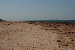
facility for shipping out the iron ore; we managed to count 7 ships out at sea
waiting to come in with another 3 docked at the wharf. We set up camp then
crossed the road onto the beach and had a very enjoyably refreshing swim in the
warm Indian Ocean. Had a nice glass of sparkly in celebration of my birthday
before dinner.
Friday 5th October: Port Hedland – Millstream National Park 322km Wendy lead
As Greg starts work at 7:00 we had an early start to the
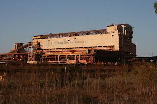
day. A bit more of a look around Port Hedland; harbour, sea front, BHP loading
plant, railway marshalling yards and salt works before parking up on the Beach
front for breakfast. Leaving Port Hedland along the Great Northern Highway we
soon moved onto the North West Coastal Highway before finally turning off to
Millstream National Park for a late morning tea stop. Thankfully hills and
escarpments now added some depth to the scenery. Meandering through the park we
stopped at Python Pool for lunch where a sudden gust of wind caught our
awnings, bending one of our polls and breaking a lug off one of Russell &
Kath’s supporting arms. – Buggar! Continuing to the south side we came across
the area where the bush fires had been and could even see smoke still rising.
This is the fire we could see from Mt Sheila a week before. We were lucky as
the park had just reopened the day before. The bush fires would have covered
thousands of square hectares and its pattern was interesting. One side of the
road burnt, the other not. Even a meter wide path was enough to stop its
progress. We found a lovely shaded spot next to a river bank to set up camp for
the night. Meet up with a young Frenchman touring on his own. His father was
French/American and his mother a Kiwi. He had started off with his girlfriend
and a mate, but the girlfriend had returned to France and his mate had meet up
with an Aussie girl so he had been left on his own.
Subscribe to:
Comments (Atom)


